- Several base maps & overlays: OpenStreetMap based MTB maps, orienteering map "MapAnt", National Land Survey's topographic & ortographic maps, hillshade and Strava heatmaps
- GPS tracks on map: from GPX file or from your Strava activities
- Create GPX routes: autorouting & straight line drawing, editing and saving as a GPX file to transfer to e.g. Garmin devices or for sharing with other people
Full functionality is available on a large screen devices: e.g. PC and iPad, subset of functionality is available on a small screen device e.g. typical smartphone.
If you want to access your Strava activity data from Bikemap app, then a Strava mandated secure authorisation process is needed to connect application with Strava.
You can share a GPX track loaded from a file as well as a Strava activity GPX track. No other information about your Strava activity is shared except GPX track. You can also share route you have drawn with Bikemap, allowing others to continue extending and modifying route.
When you share, also your map center point, map layers you have selected and zoom level are shared.
When you share a track or route you will get a link (URL) that you can share via email, Whatsapp etc. Please note that anybody receiving the link can open the track or route you shared, there are no other access control mechanisms except sharing the link with only those you want to have access.
Sharing of track or route can be canceled later. After you share you will get instructions how to cancel your share. Please save the instructions as they are specific to the track or route you shared and cannot be accessed later.
When you share a track or route it is shared as it is at the time of sharing (as a "snapshot"). Should you make any further edits to a route, those will not be reflected in the shared route, though you can obviously share again the updated route. Likewise any people who opened your shared route via link cannot make modifications to the original shared route.For sharing Bikemap needs to store your track or route and Bikemap state (map center, map layers, zoom level) to a server database. All this data is stored encrypted on the server and can only be decrypted with the link (and sharing code embedded in it) you received at the time of sharing.
NB! No warranties are given for the availability of the data you have shared and which is stored in Bikemap server database. Loss of data is possible so please do not consider sharing track / route as a reliable mechanism for saving or archiving your data.
If you enjoy MTB-map in Bikemap please consider giving back by contributing to OpenStreetMap data. OpenStreetMap (OSM) is a collaborative project to create a free editable map of the world. MTB map is based on OSM data and especially "colour coding" of trails to indicate how suitable they are for bikes to ride is entirely based on volunteers contributing to OSM data. Please refer to (in Finnish) "simple OSM editing for MTB-map" document to learn the basics.
OSM editing can be started from Bikemap app: from info-dialog use the button "Edit trails in OpenStreetMap iD-editor" to launch OSM iD-editor with the same view to the map as in Bikemap. If you have an GPX track or Strava activity open in Bikemap it will also be presented as a GPX track in the iD-editor, helping to add any new trails to OSM data and provide a useful reference.
Even small contributions to OSM data like adding or categorising a single trail for MTB riding data will make a difference and help fellow riders to discover new trails to ride.
If you encounter an error such as crash or non-working functionality when using Bikemap app please report the problem to support@finomena.fi. Please describe the problem in detailed enough way that I can try to reproduce the problem. Please also tell what device, operating system version and browser you were using when you noticed the error.
I'll try to fix all significant errors that are reported however given that this is a free service and a hobby project I will give no guarantees.
If you have feature ideas you can send those also to the same email address.
Bikemap app runs locally in your browser, however it needs to access web services for following purposes:
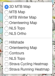
- Several map tile services including Bikemap hosted Finland MTB maps, MapAnt orienteering & contours map, NLS maps provided by Kapsi ry, Strava Heatmap and Bikemap hosted Hillshade: Any potential user metrics (e.g. IP address of user and map tiles loaded) collection of those web services is managed by the controllers for those services. Bikemap managed map tile services do not collect any user data.
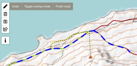
- Bikemap managed OSRM service for autorouting of routes drawn by user: service maintains access logs with IP address anonymization which are deleted daily
- Connecting with Strava requires use of Bikemap's OAuth proxy service (hosted by Amazon Web Services) which will temporarily store user's Strava access token for a maximum of 2 minutes or until Bikemap app reads it from proxy service whichever happens first.
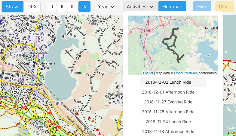
- Strava API service for presenting list of Strava activities and loading GPX track of user selected activities. When Strava functionality is used Strava will collect similar kind of usage information as they do for their own website, however Strava has only access to specific API requests that Bikemap is sending to Strava service.
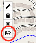
- Sharing of GPX tracks and routes requires storing of those tracks / routes to Bikemap managed sharing service. Tracks and routes are stored in service database in encrypted format and can be decrypted with the sharing key code that is not known to the sharing service.
- If user has opened an GPX track or Strava activity on Bikemap and then opens OpenStreetMap iD-editor from Bikemap info-dialog Bikemap will automatically upload first GPX track that user had opened to Bikemap hosted file upload server so that it can be opened in OpenStreetMap iD-editor to assist in editing OSM data. GPX tracks uploaded this way will be automatically deleted from file server in 24 hours.
- Bikemap app collects statistics of features used by user and sends information to Bikemap metrics service regularly. This information is collected to support further development of Bikemap features and monitor service quality. Information collected does not contain any user data, only what features were used (e.g. "route was drawn" or "Strava activity was loaded"), at what time, coordinates for map center, device & browser type, referring website and how many times Bikemap has been opened on a specific browser. To protect user privacy map center coordinates are not recorded accurately as they are rounded to one decimal accuracy for latitude and longitude (i.e. accuracy of 11,1 km). None of the above described data is shared with any 3rd party.
Furthermore Bikemap stores locally in the user's browser's local storage in PC / device following information: Strava API access token (if user has connected with Strava) and map center coordinates. This information is only available to user of the PC / device and Bikemap app.